Wetlands are complicated environments that have numerous functions in the natural world. They filter water, reduce flooding, a nd protect many species. Defining the precise boundaries of wetlands is of great importance to land management and development. This is called wetland delineation and has a scientific basis. Proper wetland mapping prevents the destruction of delicate wetlands by construction activities, agricultural activities, and conservation programs.
Wetland boundaries are important to assist developers, regulators, and other environmental professionals in making informed decisions. The U.S. Environmental Protection Agency estimates that the wetlands cover almost 6 percent of the contiguous United States and hold billions of gallons of water. These sites need to be safeguarded to ensure the safety of society and the health of the ecosystem.
The limits of water and soil interactions are determined through wetland delineation in professional ecological services. Such approaches are based on objective data and observation. The type of soil, the vegetation cover, and the presence or absence of water at different times of the year show where the wetlands start and end. The awareness of such limits will reduce risks associated with legal violations and will assist in preventing the violation of environmental legislation.
What Defines a Wetland Boundary
Wetlands are uniquely different in nature than dry land. There are three major indicators that professionals study when mapping boundaries.
Soil Characteristics and Hydrology
During some part of the year, wetland soils are usually saturated. They are organic and naturally colored. The presence of wetlands is also indicated by hydrology, or the movement of water. Saturated soils affect plant growth and the functions of an ecosystem. Soil tests indicate moisture levels and are used to tell whether a location is a wetland.
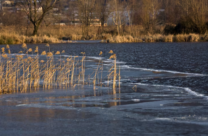
Plant Species and Vegetation Indicators
Some plants only survive in a wet environment. Plant studies show the types, density, and patterns of vegetations. The presence of species such as cattails, sedge, and willows suggests the presence of wetlands. Vegetation mapping is useful to verify the size of a wetland and to give visual testimony to the permits.
Seasonal Water Presence and Surface Indicators
Other wetlands have water seasonally. One of the boundary markers is seasonal flooding or standing water. The experts monitor such trends to understand the amount of retained and flowing water. This information is necessary to ensure that temporary and permanent wetlands are properly marked.
The Scientific Methods Used in Delineation
Wetland delineation relies on systematic scientific methods. Tools and techniques provide measurable results.
Field Surveys and Soil Sampling
Field surveys involve walking the property, taking soil samples, and noting plant species. Soil analysis measures moisture, color, and texture. This data confirms wetland presence and supports legal reports for permits.
Hydrological Studies and Water Table Measurements
Hydrology involves the observation of water flow, depth, and seasonal changes. Monitoring wells can be put in place to measure water tables. This can be used to establish whether an area has sufficient time to hold water to be termed a wetland.
Vegetation Assessment and Ecological Indicators
Plants adapted to wet habitats are detected by vegetation assessment. They include indicators such as the type of leaf, patterns of growth, and the density of the plant. This,s along with the data of the soil and water, forms a clear map of the wetland boundaries.
Why Accurate Wetland Boundaries Matter
Mapping wetland boundaries correctly has many benefits.
- Legal and Regulatory Compliance: Federal and state agencies require accurate delineation for land development. Permits depend on precise mapping.
- Protecting Wildlife and Natural Resources: Wetlands support fish, birds, and amphibians. Accurate boundaries prevent habitat loss.
- Avoiding Construction Delays and Fines: Developers save money by knowing which areas are protected and which can be built upon.
In real-world scenarios, projects that ignored wetland boundaries faced costly redesigns. One construction project in Florida had to reroute drainage systems after failing to map a seasonal wetland. Early delineation would have prevented months of delays and financial loss.
Table Showing Key Factors in Wetland Delineation
| Factor | How It Is Measured | Purpose |
| Soil Type | Sampling for moisture and composition | Determines wetland soil |
| Vegetation | Plant species, coverage, and density | Confirms wetland presence |
| Hydrology | Water flow, seasonal flooding | Maps water boundaries |
| Land Use | Human activity and nearby structures | Guides development planning |
Real-World Applications of Wetland Science
- Urban Development: Wetland delineation guides safe placement of roads, buildings, and parks.
- Agricultural Management: Farmers can plan crops without harming wetlands or violating regulations.
- Conservation Projects: Accurate boundaries help restore wetlands and protect endangered species.
Professional ecological services, such as habitat restoration, use this data to maintain biodiversity and ecosystem health. Accurate mapping also supports environmental compliance and ensures that development projects align with legal standards.
Choosing Experts for Wetland Boundary Delineation
Working with trained ecological professionals is critical. They understand soil science, hydrology, and plant ecology. Services like EcoVantage Ecological Services provide reliable wetland delineation reports. These reports are accepted by agencies for permitting and supporting sustainable land use decisions.
Experienced consultants reduce risks, prevent costly delays, and provide guidance on preserving sensitive areas. Their expertise is essential for any landowner, developer, or conservation group aiming to work responsibly with natural resources.
Bullet Points for Quick Reference
- Wetlands store billions of gallons of water
- Specific plants indicate wetland boundaries
- Soil moisture and composition guide mapping
- Seasonal flooding reveals temporary wetlands
- Professional delineation supports permits and land planning
Final Thoughts
Understanding wetland boundaries is essential for protecting ecosystems, complying with regulations, and planning development. Wetland delineation uses soil, vegetation, and hydrology data to define limits accurately. Consulting professionals ensures projects avoid delays and fines while preserving nature. EcoVantage Ecological Services demonstrates how science-based mapping improves land use decisions and safeguards wetlands for the future.
FAQs
- What is wetland delineation
Wetland delineation is the process of identifying the exact boundaries of a wetland using soil, water, and plant data. - Why is wetland delineation important
It protects ecosystems, ensures compliance with laws, and prevents project delays or fines. - Who can perform wetland delineation
Certified ecological consultants or environmental scientists conduct delineation studies. - How long does wetland delineation take
The duration depends on property size and wetland complexity. Small sites may take days, larger sites weeks. - Can wetland delineation improve land planning
Yes. Accurate mapping guides development, reduces risk, and supports sustainable land use.